The second videoconference took place on January 11, 2001 at 14.00 -15.30. Thesubject was "The waterfronts and urban space".
Participating universities:
Technical University of Gdansk, Gdansk,Poland (Dorota Wlodarczyk)
Kaunas University of Technilogy, Kaunas,Lithuania (Linas Kliucininkas)
The Baltic University Programme, Uppsala, Sweden(Lars Ryden)
| PRESENTATIONS | |
| The following students' teams from the Technical University of Gdansk, Poland made their presentations titled: | |
| 1. "Waterfront zones in Gdansk" | Malgorzata Chojnacka |
| 2. "Urban waterfront areas of high cultural value" | Maja Markiewicz, Monika Kowalczuk, Tomek Kwasnik (Please e-mail the photographs, thanks for the text) |
| 3. "Gdansk's natural waterfronts" | Małgorzata Dabrowska, Paweł Dadasiewicz, Michał Gorny (Please e-mail the text, thanks for photographs) |
| 4. "Flood hazard in the Gdansk area" | Maria Kolanczyk, Michał Karzynski |
1.WATERFRONT ZONES IN GDAŃSK
At the beginning a some information about Gdańsk:
Gdańsk, a city and site with a thousand year history ofhuman settlement, it is now the heart of an urban agglomeration with roughly onemillion residents, stretching along the shores of the Gdańsk Bay. The town issituated in northern Poland, it lies at the mouth of Vistula, the largest Polishriver. Its location on the border of various geomorphological zones meeting heregives the place its specific character. In the west the city rests on morainehills of the Gdańsk Uplands carved by glacier, criss-crossed by picturesquevalleys with streams and woods which overhang the city borders. In the east itopens onto the waters of the Gdańsk Bay sheltered by a narrow arm of the Helpeninsula which tempers the sometimes pressing thrust of the open sea. In thesouth-east the city borders on the fertile Vistula river delta, a low flatcountry Zulawy, evidencing the successful struggle of man against nature.
The first historic record of Gdańsk comes from the Life ofSt. Adalbert issued in Rome in the year 998, but it is surely much older. In1263 it was bestowed city rights, and in 1361 Gdańsk joined the HanzeaticLeague and soon became one of its major members. The citizens of Gdańsk hadlively contacts with numerous towns and regions all over Europe. In 14th and15th centuries Gdańsk, a conglomeration of several independent urban entities(the historic district of Old Town, the Castle, the Main City, the Old Suburb,the New Town) carried out several important projects.
Gdańsk, a European city and member of Hanza, linked itswell-being with the Kingdom of Poland. Though always cosmopolitan andindependent, the city recognised the importance of the state. Due to thelocation on the Vistula mouth, Gdańsk benefited immensely from trading withPoland which was its natural economic hinterland. It was in those very timesthat many magnificent buildings in Gdańsk were either erected or given theirultimate shape. Through the years craft, trade, culture, science and artimproved. In the first half of 17th century Gdańsk became the richest city ofthe Polish Republic and one of the wealthiest centers in Europe.
Late 18th century marked the end of the golden epoch of Gdańsk.Following the 2nd partition of Poland (1793) the city was annexed by Prussia andbecame isolated from its natural background.
In mid 19th century the development of industry forced thecity to spread beyond its historic outlines (the system of modern bastions andmoats). A railway line was constructed on the east side and the shipyard on thenorth, so the town changed its spatial profile. During World War II , 80 percent of the heart of ancient Gdańsk collapsed into rubble. The reconstructedGdańsk, was a different city, turned to new times. With all these changes, thecity continued to prove its historic importance playing a substantial role inthe history of Poland and Europe.
Contemporary function which Gdańsk fulfils in the region ofthe Baltic Sea and Europe, and also part that the city took in history preciselydefined it as a harbor town. The citizens of Poland and tourists from all overthe world, expect developing many public spaces connected with water and createddialog between town structures and water basins. Now a days, unfortunately watercharacter of the town does not decide the visiting-card, because it is notclearly visible.
Waterfronts existing in Gdańsk, are about 100 kilometers’length along the shore. (River side measure twice). We can divide them accordingto the basins they are situated on, and which they are connected with. Each ofthese sections has a different character, management and use, location in thestructure of the town, cultural values and possibilities of changes.
The waterfronts are, thus divided into:
2. URBAN WATERFRONT AREAS OF HIGH CULTURAL VALUE
Gdansk is considered as harbour city due to the role it used to play inPolish, Baltic Region and European history and economy, but in fact, there isvery few public waterfront spaces in the city structure that would confirm it.The existing waterfront public spaces lack proper exposition and links betweeneach other that would allow to perceive them as a part of whole, that means,waterside city structure.
We would like to say about characteristic urban spaces in Gdansk that aresituated by the water. Their value, situation and surroundings vary as well asthe role they play in urban structure and changes they require.
First of all we would like to show urban spaces that are the most importantfor the city structure and its turistic attraction.
Tourist attraction depends on:
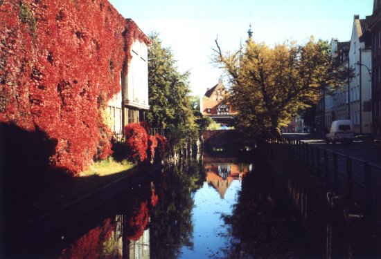
The waterfronts of Radunia Channel:
The Radunia Channel is one of the most interesting urban spaces in the Gdanskarea. It is an artificial water element reminding of high quality technologiesbeing used in Gdansk throughout ages. Channel stone walls and historicaltenement housing surroundings provide interesting contrast with the flowingwater. There are many unique sets where both faces of Radunia Channel-technical and natural- meet.
Among the most valuable we find The Mill Isle, Dom OpatowPelplinskich and the waterside part of Na Piaskach street.
Unfortunately some of the most exposed parts of the channel are the mostneglected ones to mention the place where Radunia flows into Motlawa River. Thisparticular part of Gdansk waterfront still holds pre-war atmosphere and feel inarea of Stara Stocznia, Czopowa & Grodzka streets.
The waterfronts of Potok Oliwski.
Potok Oliwski is considered as the most beautiful of all the streams thatflow through the Tricity thanks to its unique landscape and monumentalsurroundings. Its part has been used as the element of the baroque gardens inOliwa Park. The picturesque waterside along the Potok Oliwski isestablished both by the variety of special forms and countless traditionalelements.
The most valuable are:
The waterfronts of Motlawa River
and it's entrance to Martwa Wisla River,in the past surrounded by the fortifications, are the exact area of the historicCity of Gdansk. Nowadays, they are located in central part of Gdansk. Due totheir historical, cultural and architectural values they are the main point ofthe turistic interest.
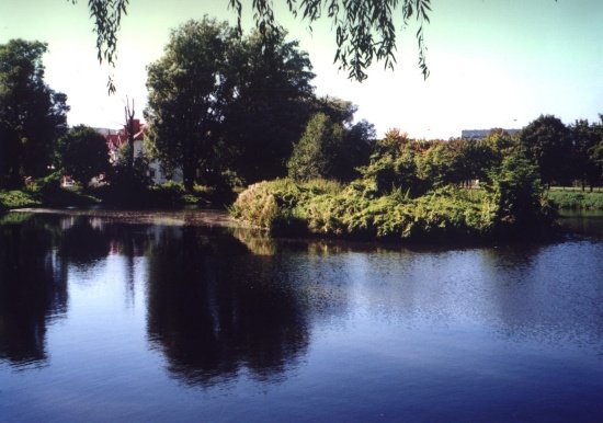
3. GDANSK'S NATURAL WATERFRONTS
4. FLOOD HAZARD IN THE GDANSK AREA
April 1829… Ice piled up on the left bank of the VistulaRiver causes water to dam up and spill over flood-barriers into Zulawy Wislane.The water breaks these flood barriers in two places and the Vistula spillsthrough both openings at a rate of 1300 m3/sec. On the evening of thesame day another flood wave reaches Gdansk and enters the city through everygates.
The water, held up by the dikes of Martwa Wisla, cannot reachthe Gulf of Gdansk and floods three quarters of the city area. The inner city,on the banks of Motlawa and the Radunia channel, is covered up by water torooftop level. All of the downtown area is flooded by water two stories high.
This had been the greatest flood tragedy in the whole historyof Gdansk. During the flood, 47 villages and an area of 340 km2 ofZulawy Wislane was submerged, the city’s entire flood protection system(ditches, channels, pumping stations) was destroyed.
The flood of 1829 was caused by a tragic coincidence. Aspring storm was raging on the Baltic Sea and it raised the water level in theGulf of Gdansk. Additionally a counter current blocked the outflow of ice fromthe Vistula River mouth. The ice created a dam, which raised the water andcaused it to break through the barriers. During the preceding 40 years theseflood barriers were much neglected, since there was no serious flood eventduring that time.
The 1829 tragedy changed people's attitude to floods. Theyrealized the dangers and decided to take action. Prussian government devised aplan called the 'Cochius-Sewerin' Project for regulating and controlling watersin the Vistula delta. Eleven years later in the winter of 1840 waters of Vistulacarved a new natural channel to the sea. The banks of this new furrow werestrengthened and technically reinforced, but this did not sufficiently lower theflood danger to Gdansk. Therefore work on another channel - the Przekop Wislywas initiated. The creation of this new watercourse, made necessary theconstruction of dams to regulate water flow. In the process the main mouth ofthe Vistula was moved and the Sobieszewska Island was created.
Current flood danger in Gdansk
For the last 100 years there was no flood in Gdansk, but wehave to ask ourselves does that mean that we are safe? The citizens of Gdansk donot consider flood to be a risk for the city, but the experts claim otherwise.According to the experts there are two main types of flood danger, which are:
The Vistula could endanger the city if the current on theGulf of Gdansk blocked the spring thaw waters carrying ice in the mouth of theriver. The barriers are still not sufficiently protected and a flood couldeasily break though them into the city and Zulawy Wislane. This is a veryrealistic and immediate danger and we have to be aware of it.
From more a long-term point of view the Sea represents adifferent hazard. The sea level is raising because of the melting of icebergsdue to global warming. There is also a geological tendency for Baltic's southernshore to descend and the Scandinavian Peninsula to raise. In consequence of thisthe sea seems to consume more and more of our land, placing us in a situation ofbattle for our shores.
There are several projects taken into consideration in orderto protect us in case of an increased flood risk. Firstly, most of the floodbarriers need to be preserved and raised, because they have settled in the muddygrounds of Zulawy Wislane and are now too low, and might soak trough. Thisshould be done as soon as possible, because during a flood rescue operationsinvolve too much improvisation in extremely difficult circumstances.
The level of protection the Gdansk flood barriers provide is99.2 percent, whereas the optimal level in our situation would be 99.7 percent.Such a high level of protection is necessary because of the great social,economic and ecological values of the flood area. The numbers indicate that wecannot feel overly safe.
Secondly, apart from the barrier reconstruction, there isneed to create a quick and efficient rescue system in case the dikes were everbroken. The main element of this system is the back-up outflow of water throughWisla Smiala, which has to be maintained clear and in good condition in case oftrouble.
Safety of an urban area is of course vital to itssustainability. The flood-endangered Gdansk area is of great social, economicaland cultural importance not only to the city itself but to the whole region.Through the reconstruction and maintenance of flood barriers as well as throughcreation of anti-flood systems and water level monitoring we must ensure thesafety of our city. Hopefully future generations will be able to benefit fromits river delta, seaside location without having to fear impending flood.